 |
| Quebec City, PQ |
Showing posts with label travels. Show all posts
Showing posts with label travels. Show all posts
Wednesday, June 12, 2013
Saturday, June 8, 2013
Beautiful Views From the Top
It has been so many years since I visited New York City (NYC). I didn't think I would ever be back just because there are so many places to visit and saving funds gets hard when you want to help on the mission field. But recently I had to (wanted to) visit an elderly relative in Quebec and decided to extend my trip much further afield. NYC was one of those stops.
In my only other visit to NYC, I wanted to visit the Empire State Building but couldn't due to very inclement weather. They had closed the Empire State Building as a result of high winds.
Would you believe that on this, my 2nd visit to NYC, the effects of Tropical Storm Andrea were being felt through pouring rain and high flood alert? We had lunch, did a bit of shopping and waited for our room to be ready. Later, when I checked into my room and looked out from the top floor toward Manhattan, it was so cloudy and foggy that I could make out only faintly some of the tallest buildings across the Hudson River. I prayed for a peaceful time and for the rains to lift as well as the sun to shine this morning. I wanted to get a photo of the Empire State Building from my room because I wasn't sure I could get a good photo from ground level in Manhattan. I also wanted to visit the Empire State Building in order to see the spectacular views from the top and make up for the disappointment of my first visit many years ago. However, I also readied myself with a story if my visit to the Observation Deck didn't happen due to the weather once again. I was going to tell friends that I had gone down to see the aftermath of Hurricane Sandy but instead I ended up being caught up in Tropical Storm Andrea.
This morning, I was so full of joy when I woke up to sunshine. The sun didn't stay constant but kept coming in and out of clouds. I found that cloudy was better for taking a photo through the glass in my top floor hotel room.
I hope you enjoyed these views. I will have a lot more of my trip to share with you when I get home.
In my only other visit to NYC, I wanted to visit the Empire State Building but couldn't due to very inclement weather. They had closed the Empire State Building as a result of high winds.
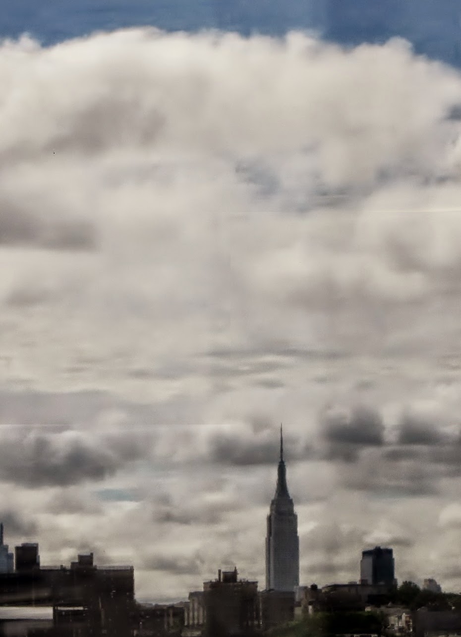 |
| View of the NYC skyline and Empire State Building from my hotel window in Secaucus, New Jersey. |
Would you believe that on this, my 2nd visit to NYC, the effects of Tropical Storm Andrea were being felt through pouring rain and high flood alert? We had lunch, did a bit of shopping and waited for our room to be ready. Later, when I checked into my room and looked out from the top floor toward Manhattan, it was so cloudy and foggy that I could make out only faintly some of the tallest buildings across the Hudson River. I prayed for a peaceful time and for the rains to lift as well as the sun to shine this morning. I wanted to get a photo of the Empire State Building from my room because I wasn't sure I could get a good photo from ground level in Manhattan. I also wanted to visit the Empire State Building in order to see the spectacular views from the top and make up for the disappointment of my first visit many years ago. However, I also readied myself with a story if my visit to the Observation Deck didn't happen due to the weather once again. I was going to tell friends that I had gone down to see the aftermath of Hurricane Sandy but instead I ended up being caught up in Tropical Storm Andrea.
This morning, I was so full of joy when I woke up to sunshine. The sun didn't stay constant but kept coming in and out of clouds. I found that cloudy was better for taking a photo through the glass in my top floor hotel room.
 |
| This is the beautiful panel you will see in the lobby of the Empire State Building. It is made of 23 Karat gold and silver. I didn't dawdle in taking photos as I wanted to get upstairs as quickly as possible. |
 |
| View of Manhattan from the Empire State Building. |
 |
| Another view of Manhattan. |
 |
| View of the Statue of Liberty. |
I hope you enjoyed these views. I will have a lot more of my trip to share with you when I get home.
Friday, June 7, 2013
Skywatch Over Lanorae, Quebec
 | |||
| I am nearing the end of my travels to Quebec, Canada and the Eastern Seaboard states. This is a photo of some lovely coloured ice fishing huts situated in a field in Lanorae, Quebec where I visited with distant relatives. |
For more Skywatch Friday photos click here.
Thursday, January 10, 2013
Journey Home - Part 3
Write it on your heart that every day is the best day in the year.
Ralph Waldo Emerson
I returned home from my Christmas travels on December 27, 2012. Part 1 of my journey photos can be viewed here. Part 2 can be viewed here. This is the last installment of this series. I hope you enjoyed the peek into the scenery around these parts.
 |
| We are at Herrling Island just before you get to the City of Chilliwack. |
 |
| I think I was just taking photo of the traffic sign and the red barn to the right of the photo. |
 |
| Chilliwack is a farming community and in this photo you see row upon row of greenhouses. |
 |
| A photo for my international readers so you can see what is on the side of the road. I think KFC is now in many countries including Kenya. It is a fried chicken fast food outlet. |
 |
| A scene from the freeway toward one of the many suburbs outside Vancouver. I think this is part of Port Coquitlam. |
 |
| We are fast approaching the new Port Mann Bridge. You can see it in the distance to the right of the photo. |
 |
| We are on the new Port Mann Bridge which has only been open about a month and cost 3.4 Billion dollars or thereabouts. It has already been closed to traffic twice due to the bad weather we've been having. They need to find solutions to the problems that have arisen thus far. It's atrocious that the bridge cost that much and can't help move the traffic in bad weather, especially when drivers have to pay a toll fee on top of it all! |
 |
| A close up view. You can see the posts are designed to join right above the cars below. This was problematic after a snow fall when icy snow bombed cars below causing numerous accidents and bridge closure just before Christmas. |
 |
| After we crossed the 2nd Narrows Bridge to the north we travelled west on the Upper Levels Hwy. (Trans-Canada Hwy. to Taylor Way and then south to Future Shop at Park Royal Mall). You can take this highway to the Sea to Sky Highway which takes you to the beautiful ski town of Whistler where many locals and celebrities go skiing. |
 | ||
| We ended our long journey with a several hour shopping expedition at the Future Shop looking for appliances. It was a busy store that day and my leg was very sore. I was not in the mood for shopping. Thank goodness my brother and nephew were there to do the "legwork". |
I was glad to finally get home to Vancouver that day!
This is my submission to Skywatch Friday. You can see the sky was very gray in the last hours of our journey. If you look at Parts 1 and 2, you will see we had a variety of skies that day.
Happy Skywatch Friday!
Wednesday, May 16, 2012
We've Covered a Lot of Miles
Hi friends,
I am back from my recent travels to visit elderly relatives.
We started our journey at 5 a.m. on Thursday, May 10, 2012. About 75 minutes later we came upon the scene in the photo below. I felt it was a symbol that we would have a nice trip.
You can see the outline of our journey on the map below. Our northward journey took us north east from Vancouver to Kamloops on Highways 1 and 5. We continued along the route shown by the upper purple coloured line which is primarily along the Yellowhead Highway. The route went through Kamloops, Barriere, Blue River, Valemont and on to Mount Robson at Jasper. We continued through to Hinton where we stopped for dinner. After a delicious dinner of calamari and caesar salad at L & W's, we drove on Highway 16 east to Edmonton and spent the night in St. Albert, north west of Edmonton at the St. Albert Inn which was very comfortable. The room rate was about $117.00 Canadian. (You can click the link in the previous line, to see the hotel rooms and amenities.)
On Friday, we drove on to a small community near Calais, Alberta, along Highways 43 and 34, where we stayed with my aunt (more about that later). If you click on the map, it will enlarge. Locate Edmonton (about the middle of the map) and move your finger/eye along the line that goes northwest until you get to Valleyview. Calais is the first stop to the west of Valleyview.
On Saturday we journeyed north along Highways 16, 43, 34 and 2, to Hines Creek, Alberta, and visited with my uncle who has recently been diagnosed with colon cancer (more about that later). From there we drove along a secondary road west to the town of Ft. St. John, BC. There we decided to have a late lunch and skip contacting more relatives to visit. Instead we drove south on Highways 97 and 2, through a town called Taylor and stopped in the City of Dawson Creek, BC, to visit another uncle. We then drove back to my aunt's place along Highways 2 and 34, in northern Alberta for one more overnight stay.
Early the next morning we drove back to Edmonton, Alberta, along Highway 43. There we visited with a third uncle who I haven't seen for about 17 years. I've been wanting to visit him because both he and his wife have suffered a lot of health challenges in recent years and they are in their late 70s so you never know what happens. After visiting for a few hours we made our way south on Highway 2, turning west at Red Deer on a secondary highway. We made our way to Highway 93 so that we could pass through the town of Rocky Mountain House and travel back to British Columbia through the Rocky Mountains. We connected in BC with Highway 1 and drove back to Kamloops, passing through the towns of Field, Golden, Revelstoke, Salmon Arm, Sicamous, Chase and then finally Kamloops. We visited mom for several hours and then headed home on Highways 5 and 1 back to Vancouver. I was glad to get home as the long trip over a short period of time always tires me out.
If you are a cross-country skier there is a wonderful ski trail through the Upper Moose Lake Loop and the trail is supposed to take you through some interesting terrain with inspiring views

The photos above end in Jasper National Park. The park is one of Canada's oldest and largest national parks. Established in 1907, Jasper was once seen as an island of civilization in a vast wilderness. More recently, it has become a popular getaway from urban life, and a special place to reconnect with nature. There are nearly 1000 km of trails in the park, thousands of campsites, tons of wildlife and the largest Dark Sky Preserve on the planet.
Our total travel distance was 2585 miles or 3514 kilometers in 5 days (excluding time spent driving around finding the places we were to visit or doing some shopping). I will be sharing more scenic photos from other parts of my journey in future posts. Some of them are even more spectacular than those I've shared in this first post.
I am back from my recent travels to visit elderly relatives.
We started our journey at 5 a.m. on Thursday, May 10, 2012. About 75 minutes later we came upon the scene in the photo below. I felt it was a symbol that we would have a nice trip.
 |
 |
| Entering Kamloops, BC where I visit my mother. |
 |
| About one hour north of Kamloops and we are well on our way up the Yellowhead Highway. |
You can see the outline of our journey on the map below. Our northward journey took us north east from Vancouver to Kamloops on Highways 1 and 5. We continued along the route shown by the upper purple coloured line which is primarily along the Yellowhead Highway. The route went through Kamloops, Barriere, Blue River, Valemont and on to Mount Robson at Jasper. We continued through to Hinton where we stopped for dinner. After a delicious dinner of calamari and caesar salad at L & W's, we drove on Highway 16 east to Edmonton and spent the night in St. Albert, north west of Edmonton at the St. Albert Inn which was very comfortable. The room rate was about $117.00 Canadian. (You can click the link in the previous line, to see the hotel rooms and amenities.)
On Friday, we drove on to a small community near Calais, Alberta, along Highways 43 and 34, where we stayed with my aunt (more about that later). If you click on the map, it will enlarge. Locate Edmonton (about the middle of the map) and move your finger/eye along the line that goes northwest until you get to Valleyview. Calais is the first stop to the west of Valleyview.
On Saturday we journeyed north along Highways 16, 43, 34 and 2, to Hines Creek, Alberta, and visited with my uncle who has recently been diagnosed with colon cancer (more about that later). From there we drove along a secondary road west to the town of Ft. St. John, BC. There we decided to have a late lunch and skip contacting more relatives to visit. Instead we drove south on Highways 97 and 2, through a town called Taylor and stopped in the City of Dawson Creek, BC, to visit another uncle. We then drove back to my aunt's place along Highways 2 and 34, in northern Alberta for one more overnight stay.
Early the next morning we drove back to Edmonton, Alberta, along Highway 43. There we visited with a third uncle who I haven't seen for about 17 years. I've been wanting to visit him because both he and his wife have suffered a lot of health challenges in recent years and they are in their late 70s so you never know what happens. After visiting for a few hours we made our way south on Highway 2, turning west at Red Deer on a secondary highway. We made our way to Highway 93 so that we could pass through the town of Rocky Mountain House and travel back to British Columbia through the Rocky Mountains. We connected in BC with Highway 1 and drove back to Kamloops, passing through the towns of Field, Golden, Revelstoke, Salmon Arm, Sicamous, Chase and then finally Kamloops. We visited mom for several hours and then headed home on Highways 5 and 1 back to Vancouver. I was glad to get home as the long trip over a short period of time always tires me out.
 | |||
| This map shows our route beginning at Kamloops but we drove to Kamloops from Vancouver. It takes about 4 hours (includes stopping for coffee/gas). |
 |
| We were surprised to run into snow just before we got to the Rocky Mountains. |
 |
| You can see it is snowing at the mountain top. |
 |
| Snow capped mountains are always so beautiful. |
 |
| We are entering the Town of Valemount. We are still in British Columbia. |
 |
| The town is in a picturesque area. |
 |
| Another shot of the mountains at Valemount. |
 |
| Here were are nearing Mount Robson which is on the border of British Columbia and Alberta. This day it was shrouded in mist and snow. Apparently the top of the mountain is often obscured by clouds and/or fog. |
 |
| A sign tells us we are now entering Mount Robson. |
 |
| Here we are passing Moose Lake in Alberta. It looks so cold. |
 |
| In fact Moose Lake is still very much frozen. |

 |
| These big horn sheep were grazing on the side of the highway. |
 |
| I was lucky to be able to capture an eagle flying overhead. |
The photos above end in Jasper National Park. The park is one of Canada's oldest and largest national parks. Established in 1907, Jasper was once seen as an island of civilization in a vast wilderness. More recently, it has become a popular getaway from urban life, and a special place to reconnect with nature. There are nearly 1000 km of trails in the park, thousands of campsites, tons of wildlife and the largest Dark Sky Preserve on the planet.
Our total travel distance was 2585 miles or 3514 kilometers in 5 days (excluding time spent driving around finding the places we were to visit or doing some shopping). I will be sharing more scenic photos from other parts of my journey in future posts. Some of them are even more spectacular than those I've shared in this first post.
Click here for Our World Tuesday and more scenic photos from around the world.
Sunday, April 1, 2012
Photo Journey to Kamloops
 |
| This photo is taken on the highway going through Chilliwack, an agricultural area. |

 |
| This photo is past the City of Hope. We are climbing up to the summit of the mountain range. There used to be a toll bridge here for many years but it is now gone. Instead they are building a toll bridge closer to where I live. |
 |
| I am always awed by this sheer rock face on the mountain no matter what the season. |
 |
| There was very little traffic on the highway going up or coming home. It causes me to think that the price of gas has so many people deciding not to travel far these days. These photos show you how much snow has fallen this year. There is still plenty of it. In fact, a light snow fell on the drive north and more flurries fell on the return journey. |


 |
| When we get to this flat stretch it means we are nearing the City of Merritt which is about 1 hour south of Kamloops. For years Merritt has been known as the home of the Merritt Mountain Music Fest, a large country music festival held every summer. This year it will be held July 19-22, 2012. |

 |
| It is hard to see but if you look at the lower part of the photo you will see some of the buildings (homes and businesses) that make up part of Merritt. |
 |
| We are now nearing the City of Kamlops; my destination. |
 |
| We are missing the main town by driving down the side of a mountain into the North Shore. This scene is always very pretty at night when the city lights are shining. |
 |
| Normally the weather would be very warm by now but it is still chilly by Kamloops standards. This is a view of the north shore of the city, Bachelor heights to the top left and the Kamloops Industrial Park and Raleigh in the far distance on the right. You keep driving on the Trans Canada Highway north beyond those mountains. You can read a bit more about that journey here. |
Once I got to my destination I quickly set about doing the work mom requested to re-arrange her closet and her drawers, put a stacking shelf on her dresser to hold her products and locate several photos in her storage tubs. I was able to tape all her photos inside the picture frame and hang it up. I also managed to have dinner with my niece and visit mom for a bit. The journey home was quiet and easy. I arrived home in the wee hours of the morning.
I hope you enjoyed the journey with me.
I hope you enjoyed the journey with me.
Monday, August 29, 2011
Grande Prairie to Chetwynd ~ The Journey Continues
Last time I left off on my journey to northern Alberta and British Columbia (BC), I was overnighting in Grande Prairie. I took a little break from blogging about my journey to feature the critical food situation in the Horn of Africa. If you missed that post, please click here. I'm so glad you've joined me for the continuation of my tour through northern BC and throughout Alberta.
After we left the City of Grande Prairie, Alberta we went east to the small town of Valleyview which is located about 115 kms away.
Here again is the map with the route marked in black. Please click on any photo to enlarge it.

Valleyview isn't a very big town. It has a population of under 2000 people but it serves a catchment area of about 5000 people so it has all the basic services.
After we leave Valleyview we are returning west. This time we are going to Chetwynd in northern BC. Before we get there we have to pass through Grande Prairie again. There are a number of small farming towns beyond that and we will pass through some of them. After Grande Prairie, the next largest city will be Dawson Creek in British Columbia.
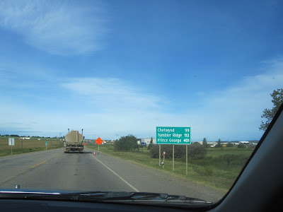
Chetwynd is home to 3000 local residents with a trading area of approximately 7000 people. Residents of Chetwynd enjoy a four season playground of forests, rolling hills, snow capped mountains, fields and crystal clear lakes and rivers. They even have an excellent recreation complex with wave pool, team-size hot tub, sauna, six sheet curling rink, ice arena, skateboard park, sports fields, parks and trails help to make Chetwynd a great place to live and raise a family though I've never lived there myself.
After leaving the wake, we have to drive back to Dawson Creek to find a hotel or motel room as every room in Chetwynd is fully booked. Apparently a mine has opened or reopened and there are no rooms anywhere to be had. Working men come from far to work in the mine and they live in the hotel and motel rooms all around. We have to return to Chetwynd in the morning to join the funeral service and the meal afterwards with extended family and friends before we depart.

Here again is the map with the route marked in black. Please click on any photo to enlarge it.

Valleyview isn't a very big town. It has a population of under 2000 people but it serves a catchment area of about 5000 people so it has all the basic services.
 |
| The local Co-Op (cooperative) would be the place to purchase groceries and household items. |
 |
| You can see from the signage that Dawson Creek is a few hours drive from where we are. |
 |
| You will see these kind of silos all over the north. They hold the harvested grains. Some are wooden silos, some are cement, some are metal. |
 |
| I just had to take photo of this giant beaver sculpture. It wasn't there when I went through this town called Beaverlodge many years ago. At least I do not remember it and how could one forget such a big sculpture? This mammal is the national animal of Canada and at one time was a very important pelt for the early fur trade in Canada. In the late 1600s and early 1700s, the fashion of the day demanded fur top-hats, which needed beaver pelts. As these hats became more popular, the demand for the pelts grew. Explorers were sent deep into the North American wilderness to trap and trade for furs with local natives. |
 |
| I had to take photo here as it is where my mother's mother, my grandmother is buried. It is a picturesque area near a lake. I never knew my grandmother as she died when my mother was very small. |
 |
| I love this photo. It shows the evergreen forest and the fireweeds that you see all over the north country. |
 |
| Here we are now in British Columbia in the small City of Dawson Creek. It has grown a lot in the past decade. Almost all of these places in the immediate foreground of the photo are new. |
 |
| I had to take photo of these big farm tractors, thrashing machines and other equipment. They are used for harvesting in the large farm fields. This place has been here for decades only now you can buy equipment in different colours. Long ago the predominant colour in the store's lot was green. |
 |
| Here is another Co-op. You can see the cement silos in the background. |
 | ||||||
| You will come across this sign no matter which direction you are heading on the highway. |
 |
| We are on our way now to Chetwynd in northern British Columbia. That is where my aunt is being laid to rest. |

 |
| You can see in the far horizon that we are back in mountainous country. |
 |
| Beyond the trees you can see Table Mountain which is located at East Pine. I think it is so pretty and you can see it for miles and miles. |
 |
| We begin our descent into the valley as we are now nearing Chetwynd. |
 |
| This is the town's welcome sign for visitors. |
Chetwynd is home to 3000 local residents with a trading area of approximately 7000 people. Residents of Chetwynd enjoy a four season playground of forests, rolling hills, snow capped mountains, fields and crystal clear lakes and rivers. They even have an excellent recreation complex with wave pool, team-size hot tub, sauna, six sheet curling rink, ice arena, skateboard park, sports fields, parks and trails help to make Chetwynd a great place to live and raise a family though I've never lived there myself.
 |
| This is the hall where the family and friends will sit with the body of the deceased and offer prayers as well as share a meal and some memories. I've decided not to share photos of this part of the trip or of the burial. Suffice to say that everything was well planned and it was a good send off for my aunt. I was happy to have made it for the celebration of her life. |
After leaving the wake, we have to drive back to Dawson Creek to find a hotel or motel room as every room in Chetwynd is fully booked. Apparently a mine has opened or reopened and there are no rooms anywhere to be had. Working men come from far to work in the mine and they live in the hotel and motel rooms all around. We have to return to Chetwynd in the morning to join the funeral service and the meal afterwards with extended family and friends before we depart.
 |
| On the drive back to Dawson Creek, I am pleased to spot this moon in the far distance. |
 |
| As I get closer I am able to capture the moon in full. |
 | |||||
| Once again we have to stop in several places and enquire about rooms. I manage to find one at the George Dawson Inn. It was a very large room on the ground for and ended up costing $135.00 plus lots of tax. At that point, I was too tired to care. I just want to get to sleep. I really thought I took some photos of the rooms but I might only have dreamt it because I can't seem to find them. |
I hope you have enjoyed this part of the tour. It is my submission to the inaugural edition of Our World Tuesday meme. Thank you to ladies who are carrying on in the tradition of Klaus Peter's meme, My World Tuesday. God rest his soul. Please click on the link to join in with Our World Tuesday.
In the next post I will be heading home through Alberta taking a different route than the one we arrived on. I hope you can join me then.
Subscribe to:
Posts (Atom)
Skywatch Friday
Hello friends and fellow bloggers, I hope you are all fine this beautiful day. These photos are from a walk to a small local park. Some tre...

-
 After some glorious sunny days, it started to rain again as is the norm in our Winter on the West Coast of Canada. It rained qui...
 -
This is a lovely gospel song sung in Swahili and has special meaning for me. It is special because on my first trip to Kenya a gr...
-
 "Better keep yourself clean and bright; you are the window through which you must see the world." -- GEORGE BERNARD SHAW Cli...
