Thursday, September 1, 2011
Monday, August 29, 2011
Grande Prairie to Chetwynd ~ The Journey Continues
Last time I left off on my journey to northern Alberta and British Columbia (BC), I was overnighting in Grande Prairie. I took a little break from blogging about my journey to feature the critical food situation in the Horn of Africa. If you missed that post, please click here. I'm so glad you've joined me for the continuation of my tour through northern BC and throughout Alberta.
After we left the City of Grande Prairie, Alberta we went east to the small town of Valleyview which is located about 115 kms away.
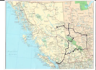
Here again is the map with the route marked in black. Please click on any photo to enlarge it.
Valleyview isn't a very big town. It has a population of under 2000 people but it serves a catchment area of about 5000 people so it has all the basic services.
After we leave Valleyview we are returning west. This time we are going to Chetwynd in northern BC. Before we get there we have to pass through Grande Prairie again. There are a number of small farming towns beyond that and we will pass through some of them. After Grande Prairie, the next largest city will be Dawson Creek in British Columbia.
Chetwynd is home to 3000 local residents with a trading area of approximately 7000 people. Residents of Chetwynd enjoy a four season playground of forests, rolling hills, snow capped mountains, fields and crystal clear lakes and rivers. They even have an excellent recreation complex with wave pool, team-size hot tub, sauna, six sheet curling rink, ice arena, skateboard park, sports fields, parks and trails help to make Chetwynd a great place to live and raise a family though I've never lived there myself.
After leaving the wake, we have to drive back to Dawson Creek to find a hotel or motel room as every room in Chetwynd is fully booked. Apparently a mine has opened or reopened and there are no rooms anywhere to be had. Working men come from far to work in the mine and they live in the hotel and motel rooms all around. We have to return to Chetwynd in the morning to join the funeral service and the meal afterwards with extended family and friends before we depart.
Here again is the map with the route marked in black. Please click on any photo to enlarge it.
Valleyview isn't a very big town. It has a population of under 2000 people but it serves a catchment area of about 5000 people so it has all the basic services.
 |
| The local Co-Op (cooperative) would be the place to purchase groceries and household items. |
 |
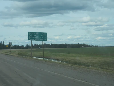
| You can see from the signage that Dawson Creek is a few hours drive from where we are. |
 |
| You will see these kind of silos all over the north. They hold the harvested grains. Some are wooden silos, some are cement, some are metal. |
 |
| I had to take photo here as it is where my mother's mother, my grandmother is buried. It is a picturesque area near a lake. I never knew my grandmother as she died when my mother was very small. |
 |
| I love this photo. It shows the evergreen forest and the fireweeds that you see all over the north country. |
 |
| Here we are now in British Columbia in the small City of Dawson Creek. It has grown a lot in the past decade. Almost all of these places in the immediate foreground of the photo are new. |
 |
| Here is another Co-op. You can see the cement silos in the background. |
 | ||||||
| You will come across this sign no matter which direction you are heading on the highway. |
 |
| We are on our way now to Chetwynd in northern British Columbia. That is where my aunt is being laid to rest. |
 |
| You can see in the far horizon that we are back in mountainous country. |
 |
| Beyond the trees you can see Table Mountain which is located at East Pine. I think it is so pretty and you can see it for miles and miles. |
 |
| We begin our descent into the valley as we are now nearing Chetwynd. |
 |
| This is the town's welcome sign for visitors. |
Chetwynd is home to 3000 local residents with a trading area of approximately 7000 people. Residents of Chetwynd enjoy a four season playground of forests, rolling hills, snow capped mountains, fields and crystal clear lakes and rivers. They even have an excellent recreation complex with wave pool, team-size hot tub, sauna, six sheet curling rink, ice arena, skateboard park, sports fields, parks and trails help to make Chetwynd a great place to live and raise a family though I've never lived there myself.
After leaving the wake, we have to drive back to Dawson Creek to find a hotel or motel room as every room in Chetwynd is fully booked. Apparently a mine has opened or reopened and there are no rooms anywhere to be had. Working men come from far to work in the mine and they live in the hotel and motel rooms all around. We have to return to Chetwynd in the morning to join the funeral service and the meal afterwards with extended family and friends before we depart.
 |
| On the drive back to Dawson Creek, I am pleased to spot this moon in the far distance. |
 |
| As I get closer I am able to capture the moon in full. |
I hope you have enjoyed this part of the tour. It is my submission to the inaugural edition of Our World Tuesday meme. Thank you to ladies who are carrying on in the tradition of Klaus Peter's meme, My World Tuesday. God rest his soul. Please click on the link to join in with Our World Tuesday.
In the next post I will be heading home through Alberta taking a different route than the one we arrived on. I hope you can join me then.
Friday, August 26, 2011
Food Relief in the Horn of Africa
Hello friends and fellow bloggers,
I have a guest post today from my friend Jonah in Kenya. He has recently participated in food relief for those affected by famine in the Horn of Africa and specifically the Maasai who live in Kenya and the Somalians that have fled Somalia to find food. I will continue with my series on my northern Canada travels soon.
As you might have read in the leading newspapers, there is a very bad drought in northern Kenya, in Somalia and Ethiopia. Christians here and several organizations have decided to do something about it and I got involved too. (You can click on any of the photos to enlarge).
In the pictures you can see that we visited and took food relief to the Maasai people and the Somalians providing much needed water and other supplies. I think we have got to do something. At least visit these people and give what we have.
I will be travelling there again. Maybe next week.
You can help raise awareness of the Missions of Hope by using the share buttons at the bottom of this post. You can help the Missions of Hope participate in food relief by sending donations.
Click here to be taken to the donate page. Thank you!
I have a guest post today from my friend Jonah in Kenya. He has recently participated in food relief for those affected by famine in the Horn of Africa and specifically the Maasai who live in Kenya and the Somalians that have fled Somalia to find food. I will continue with my series on my northern Canada travels soon.
~~~~~~~~~~~~~~~~
As you might have read in the leading newspapers, there is a very bad drought in northern Kenya, in Somalia and Ethiopia. Christians here and several organizations have decided to do something about it and I got involved too. (You can click on any of the photos to enlarge).
In the pictures you can see that we visited and took food relief to the Maasai people and the Somalians providing much needed water and other supplies. I think we have got to do something. At least visit these people and give what we have.
I will be travelling there again. Maybe next week.
Partner with us and let's help those in great need.
You can help raise awareness of the Missions of Hope by using the share buttons at the bottom of this post. You can help the Missions of Hope participate in food relief by sending donations.
Click here to be taken to the donate page. Thank you!
Tuesday, August 23, 2011
The Journey Continues - Hinton to Hines Creek
On the morning we were leaving Hinton we took a drive through the town looking for a place to have breakfast. We stopped at a fast food place then made our way back to the highway heading north. We passed by the mall you see in the photo above. The morning was overcast and a bit crisp and rain was threatening.
We continued our drive through a secondary highway to Grande Prairie in Northern Alberta. You can click on any of the photos to enlarge them. You will often see smudges and smears on the car windshield. When you are driving fast in the north, many insects and bugs hit against the car and make marks all over the windshield when they splatter due to the impact. My brother kept telling me that it would add character to my photos when I complained of the dirty windshield. There was no point to clean the windshield because there is no way it would stay clean!
This stretch of highway was very busy with work crews who are widening the road though I didn't take photos of the workers. There aren't a lot of towns or cities along this highway just one place called Grande Cache.
Grande Cache is the only real stop before you get to the City of Grande Prairie, Alberta which is where we planned to spend the night. So we stopped at this tourist information centre you see in the photo below and used the rest room. I also picked up some maps and purchased a DVD entitled "Long Road Home" about the descendants of several Metis families who were evicted from the Athabasca Valley when the Canadian Government created the "Jasper Forest Park".
Then I took a few quick photos of these new looking wood plaque structures and teepees (tipis) made of wood and canvas. The tipis are the traditional homes of the Indian people in historical times.
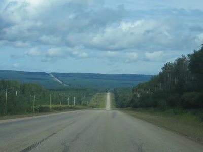
Then it was back onto the highway north. You can see the highway stretching for miles and miles. If you look at the photo below, the highway goes up the mountain to the left.
The area in the next photo is quite beautiful and as we descend into the valley we can see the Smoky River down below. I was to discover that we passed this river several times throughout our journey north. It is a major tributary of the Peace River and was given the name by Cree Indians. The name Smoky River describes "smouldering beds of coal in the riverbank".
Now and then I came across these fields of hay for the livestock. This sight is extremely typical of this area.
This signage was at the edge of the City of Grande Prairie.
You can see that Grande Prairie really is on the prairie. The land here is very flat. The city is located on the southern edge of the Peace River Country and has a population of approximately 50,000 people. This city is among the fastest growing cities in Canada and it's major industries include oil and gas, agriculture, forestry, and food services.
I didn't take many photos of the city itself just around the outlying approaches into the city. The photo below is taken at the front entry to our hotel for the night, the Sandman Inn. It was nice to be greeted by hanging baskets and there were colourful plants in planters on the ground also.
As soon as we checked into the hotel and had a short rest we set out again to the north to visit my uncle.
Along the way I saw that there is yet more road improvements being made. In this case, culverts were being replaced at a bridge.
I wanted to be sure to take photos of the rolling fields and the crops as in the view below. This scene is very typical of the area.
I cannot remember the name of the town photographed in part below but as we zipped by I noticed the large tipe (teepee) and I wanted a photograph. The tipi (teepee) is the tall, pointed structure to the right of the photo. It is oversized so it is probably a tourist attraction rather than a dwelling.
I took a lot of photos of signage along the way. In Alberta there are numerous highways and small towns everywhere.
Once again we descend into a valley and pass by the Smoky River.
The scene below is another scene which is quite typical of the area around Grande Prairie and surrounding environs.
We are getting close to the turn off for Hines Creek which is our destination.
I was amazed at the number of old wooden buildings in Alberta. A lot of them seem to have been used for grain and crop storage.
Another thing I noticed was a lot of swamps. There were an amazing number of swamps. We have nothing like this in British Columbia. I mean the swamps were extremely plentiful. Not only that but water was seeping out of the earth along the sides of the highway in a number of places.
Now we enter the small town of Hines Creek where we visit an uncle. He told us it had been raining a lot this summer. That explained all the water in the swamps and along the highways.
This is the nice signage that welcomes us to town and which is where I think the town's museum is located.
After our visit to this town, we drove back to the main highway and north again to the small town of Fairview which I had never been to before. It is only 13 miles from the main highway.
 |
| I'm not sure but I think this is where the aquatic centre is as symbolized by the wavy blue lines painted on the building. |
 |
| This is a view through one of the streets in town. |
 |
| This is the approach back into Grande Prairie from the north. |
 |
| What struck me about the city of Grande Prairie is just how many white buildings there were. They stood out in the flatness of the prairies. |
The coffee, tea and coffee maker were in the room as well as a microwave and a mini-fridge for storing drinks. I took a few moments to go downstairs to the whirlpool before bed time but the whirlpool was not that great. It didn't have very strong bubbles or water movement.
This room was well priced at $79.95 Canadian per night plus about 9% tax. It was a good reduction from the usual price of $135.00 a night. The deal was obtained through on line booking. Available hotels rooms in this city were very scarce so we felt fortunate to get one. However, my room was exceptionally hot even with the air conditioning on. I even tried an open window but that didn't help either.
This concludes my second post on my journey depicted by the map below. I hope you enjoyed it and that you will join me again soon for a continuation of the journey.
The next part of this series will show photos and describe the towns on the way to Chetwynd, British Columbia.
Subscribe to:
Posts (Atom)
Skywatch Friday ~ May 16, 2025
Hello everyone, After some sunny but not yet quite hot weather, we are now getting more spring showers. You know the old saying? April show...

-
I've been busy with a little of this and that over the past few days and still fighting a bit of cold symptoms. I've been taking my ...
-
This is a lovely gospel song sung in Swahili and has special meaning for me. It is special because on my first trip to Kenya a gr...
-
Thank you and a big welcome to my newest followers: Alan (an awesome photoblogger), Ms. Burrito (a 5 year old emerging blogger), Paco (who ...


